(Add cave section) |
(Add note regarding conditions, remove unnecessary cautions from cave section) |
||
| (13 intermediate revisions by 2 users not shown) | |||
| Line 1: | Line 1: | ||
{{Divesite_infobox | {{Divesite_infobox | ||
|coordinates= | |coordinates=29.9967499, -82.9663841 | ||
|region=Southeast US | |region=Southeast US | ||
|site_access_type=Shore | |site_access_type=Shore | ||
|depth_range=15-129ft | |depth_range=15-129ft | ||
| | |type=Cave}} | ||
Little River is an extensive submerged cave system. It is located near Branford in north central Florida | |||
Little River is a second magnitude spring that runs into the Suwannee River. The spring is the entrance to an extensive submerged cave system. It is located near Branford in north central Florida and is a popular site for open water, cavern and cave diving. It is often used as a training site for cavern and cave divers. | |||
Conditions here normally offer excellent visibility, warm water, and an abundance of surface life for open water divers. Cavern divers will find a medium sized but disappointingly brief cavern. For cave divers this system is extensive and full of interesting, varied passages at moderate depths protected by brisk flow. | |||
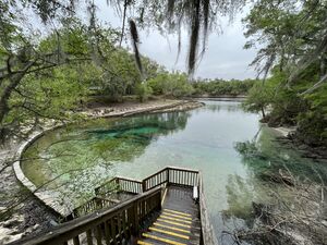
[[File:Little River Spring.jpg|alt=Photo of Little River Spring and the spring run, April 2023. View from the top of the steps leading down to the water. At center frame is a large turqoise spring basin with the banks surrounded by a concrete walkway. The view is from the top of a long flight of stairs perhaps 50ft above the water overlooking the run.|thumb|Little River Spring, April 2023. Spring vent (cave entrance) is visible on the left side of the picture, just left of the water glare.]] | |||
==Details== | ==Details== | ||
===Location=== | ===Location=== | ||
Travel north to O’Brien, turn left on CR 349; travel 3.5 miles west and the entrance is on the left.<ref>https://map.mysuwanneeriver.com/tracts/little-river-119/</ref> | Travel north to O’Brien, turn left on CR 349; travel 3.5 miles west and the entrance is on the left.<ref>https://map.mysuwanneeriver.com/tracts/little-river-119/</ref> | ||
===Depth=== | ===Depth=== | ||
| Line 25: | Line 27: | ||
Visibility is typically very good, 100' or greater. Water temperatures remain within a few degrees of 70F year round throughout the system. | Visibility is typically very good, 100' or greater. Water temperatures remain within a few degrees of 70F year round throughout the system. | ||
As with all caves on the Suwannee, river levels can influence this system substantially, so get a condition report before going. | |||
===Facilities=== | ===Facilities=== | ||
| Line 34: | Line 38: | ||
The entrance to the cave is via a large spring vent in 15' of water. There are two large trees / logs in the entrance which are used as primary tie offs. Place your primary tie on one of them. It is typically easier to run a line on the left side of the cave. There is a piece of rebar installed on the left side of the cavern entrance just below the tree. It is there in order to place a secondary tie off. Locations for secondaries are otherwise limited. | The entrance to the cave is via a large spring vent in 15' of water. There are two large trees / logs in the entrance which are used as primary tie offs. Place your primary tie on one of them. It is typically easier to run a line on the left side of the cave. There is a piece of rebar installed on the left side of the cavern entrance just below the tree. It is there in order to place a secondary tie off. Locations for secondaries are otherwise limited. | ||
The gold line begins at the bottom of the cavern at approximately 65' depth within the daylight zone. It is no longer tied off 75ft into the cave on the wall as described by Extreme Exposure<ref name=":0">https://extreme-exposure.com/little-river/</ref>. | The gold line begins at the bottom of the cavern at approximately 65' depth within the daylight zone. It is no longer tied off 75ft into the cave on the wall as described by Extreme Exposure<ref name=":0">https://extreme-exposure.com/little-river/</ref>. | ||
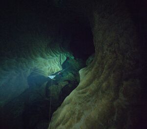
[[File:Little river big tee.jpg|thumb|Oversized line arrow marking the divergence of the Serpentine and Merry-go-round tunnels]] | |||
At around 250 feet from the start on the left side, you'll encounter the first marked jump for the "mud tunnel". Opting for this route can shorten your travel time by approximately 3 to 5 minutes, thanks to the less intense flow. However, it's important to note that the "mud tunnel" tends to be quite silt-laden and offers a significantly narrower space between the floor and ceiling. This route eventually guides divers to rejoin the main route (where another jump is necessary), leading back into the stronger flow.<ref name=":0" /> | At around 250 feet from the start on the left side, you'll encounter the first marked jump for the "mud tunnel". Opting for this route can shorten your travel time by approximately 3 to 5 minutes, thanks to the less intense flow. However, it's important to note that the "mud tunnel" tends to be quite silt-laden and offers a significantly narrower space between the floor and ceiling. This route eventually guides divers to rejoin the main route (where another jump is necessary), leading back into the stronger flow.<ref name=":0" /> | ||
At ~ | At ~630' the passage diverges into two tunnels which rejoin some 300' later (by either route) in the Florida Room. This divergence is a tee in the gold line marked by a large oversized arrow. | ||
==== Maps ==== | ==== Maps ==== | ||
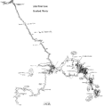
Purchasing a site map is highly recommended. The most recent map is very high quality - among the best maps of any cave in Florida - and is made from a survey completed in 2020. It is available from Extreme Exposure and Cave Country Dive Shop in High Springs. There is a high quality preview available on Extreme Exposure's website [https://extreme-exposure.com/little-river-springs-map-new/ here]. | Purchasing a site map is highly recommended. The most recent map is very high quality - among the best maps of any cave in Florida - and is made from a survey completed in 2020. It is available from Extreme Exposure and Cave Country Dive Shop in High Springs. '''There is a high quality preview available on Extreme Exposure's website [https://extreme-exposure.com/little-river-springs-map-new/ here].''' The maps below are the previous system maps and are nowhere near as good.<gallery> | ||
File:Little river cave 2.gif | |||
File:Little river decorative.jpg|Decorative map | |||
File:Little river cave 1.jpg | |||
File:Little river cavern.jpg|Cavern profile view | |||
File:Little River notfornavigation map.jpg|Readable map with a large censor box; shows the first ~900ft and Harper Tunnel | |||
</gallery> | |||
==== Notes ==== | ==== Notes ==== | ||
* As of 2023 many of the major jumps in Little River, such as Harper Tunnel, are unmarked. | * As of 2023 many of the major jumps in Little River, such as Harper Tunnel, are unmarked. | ||
* Harper Tunnel | * Harper Tunnel contains fragile clay banks which can be permanently damaged by misplaced fins or poor buoyancy | ||
* There is a convenient pocket that is a good decompression spot located out of the flow on the right side of the flow at 20ft in the cavern zone, provided it is not closed off by lines. | * There is a convenient pocket that is a good decompression spot located out of the flow on the right side of the flow at 20ft in the cavern zone, provided it is not closed off by lines. | ||
==Access== | ==Access== | ||
| Line 58: | Line 67: | ||
==== Open water ==== | ==== Open water ==== | ||
Be mindful of cavern/cave divers in and around the spring vent. | Be mindful of cavern/cave divers in and around the spring vent. | ||
'''Cavern/Cave''' | |||
Get a site briefing and conditions report from one of the local dive shops, such as Cave Country Dive Shop or Extreme Exposure, before going. | |||
==See== | ==See== | ||
| Line 65: | Line 78: | ||
==== Cavern/cave ==== | ==== Cavern/cave ==== | ||
There is a lot of variety on the gold line. Take two dives to dive each side of the gold line tee at 400' (Serpentine and Merry Go Round tunnels) | |||
===Life=== | ===Life=== | ||
| Line 77: | Line 90: | ||
===Hazards=== | ===Hazards=== | ||
* Do not enter the overhead environment if you | * Do not enter the overhead environment if you lack the required training | ||
* Be especially mindful of lines if you are doing a cavern or cave dive. Little River is used as a training site, flow is typically quite high, and good tie-offs are limited frequently resulting in poorly placed lines. | * Be especially mindful of lines if you are doing a cavern or cave dive. Little River is used as a training site, flow is typically quite high, and good tie-offs are limited frequently resulting in poorly placed lines. | ||
* Entry can be tricky, especially in backmount. The walk to the water is long and tiring, and rocks are very slippery around the shore. It is best to find deep water as quickly as possible rather than walk extended distances over uneven, slippery rocks. | * Entry can be tricky, especially in backmount. The walk to the water is long and tiring, and rocks are very slippery around the shore. It is best to find deep water as quickly as possible rather than walk extended distances over uneven, slippery rocks. | ||
==Nearby== | ==Nearby== | ||
| Line 95: | Line 104: | ||
[[Category:Dive sites]] | [[Category:Dive sites]] | ||
{{IsPartOf| | {{IsPartOf|Suwannee River Basin}} | ||
Latest revision as of 03:52, 22 May 2024
| Site Info | |
|---|---|
| Type | Cave |
| Coordinates | 29.9967499, -82.9663841 |
| Region | Southeast US |
| Access via | Shore |
| Depth range | 15-129ft |
Little River is a second magnitude spring that runs into the Suwannee River. The spring is the entrance to an extensive submerged cave system. It is located near Branford in north central Florida and is a popular site for open water, cavern and cave diving. It is often used as a training site for cavern and cave divers.
Conditions here normally offer excellent visibility, warm water, and an abundance of surface life for open water divers. Cavern divers will find a medium sized but disappointingly brief cavern. For cave divers this system is extensive and full of interesting, varied passages at moderate depths protected by brisk flow.

Details[edit | edit source]
Location[edit | edit source]
Travel north to O’Brien, turn left on CR 349; travel 3.5 miles west and the entrance is on the left.[1]
Depth[edit | edit source]
The cavern entrance is at roughly 15ft, descending quickly to 65ft. From there the cave progressively descends to ~100ft and thereafter stays in the 80-110ft range for most of the system. Maximum system depth is 129ft.
Topography[edit | edit source]
Entrance to the cave is via a large spring vent in 15' of water. This vent feeds the expansive spring run that flows into the Suwannee after a short distance. There is typically a strong boil located over the spring vent.
The floor is primarily rock and largely free of silt and particulate along the gold line.
Conditions[edit | edit source]
Little River is a second magnitude spring. Flow is typically high to very high. Gold line passage remain relatively small, thus flow remains relatively high, until around 900' penetration. After this point the cave opens up and flow becomes more manageable.
Visibility is typically very good, 100' or greater. Water temperatures remain within a few degrees of 70F year round throughout the system.
As with all caves on the Suwannee, river levels can influence this system substantially, so get a condition report before going.
Facilities[edit | edit source]
There are several porta-potties at the site, but these are frequently disgusting and should be avoided if possible. There are a limited number dive benches (4 total, with 2 sides each, as of 2023). In mid 2023 Suwannee River Management placed a couple of large gear carts in the parking lot. These are for public use and are intended to assist divers in transporting equipment to the water's edge.
The parking lot is elevated perhaps 50ft above the water level. Access is via one of two long staircases or a handicap-accessible ramp that leads to the waters edge.
Cave[edit | edit source]
The entrance to the cave is via a large spring vent in 15' of water. There are two large trees / logs in the entrance which are used as primary tie offs. Place your primary tie on one of them. It is typically easier to run a line on the left side of the cave. There is a piece of rebar installed on the left side of the cavern entrance just below the tree. It is there in order to place a secondary tie off. Locations for secondaries are otherwise limited. The gold line begins at the bottom of the cavern at approximately 65' depth within the daylight zone. It is no longer tied off 75ft into the cave on the wall as described by Extreme Exposure[2].

At around 250 feet from the start on the left side, you'll encounter the first marked jump for the "mud tunnel". Opting for this route can shorten your travel time by approximately 3 to 5 minutes, thanks to the less intense flow. However, it's important to note that the "mud tunnel" tends to be quite silt-laden and offers a significantly narrower space between the floor and ceiling. This route eventually guides divers to rejoin the main route (where another jump is necessary), leading back into the stronger flow.[2]
At ~630' the passage diverges into two tunnels which rejoin some 300' later (by either route) in the Florida Room. This divergence is a tee in the gold line marked by a large oversized arrow.
Maps[edit | edit source]
Purchasing a site map is highly recommended. The most recent map is very high quality - among the best maps of any cave in Florida - and is made from a survey completed in 2020. It is available from Extreme Exposure and Cave Country Dive Shop in High Springs. There is a high quality preview available on Extreme Exposure's website here. The maps below are the previous system maps and are nowhere near as good.
-
-
Decorative map
-
-
Cavern profile view
-
Readable map with a large censor box; shows the first ~900ft and Harper Tunnel
Notes[edit | edit source]
- As of 2023 many of the major jumps in Little River, such as Harper Tunnel, are unmarked.
- Harper Tunnel contains fragile clay banks which can be permanently damaged by misplaced fins or poor buoyancy
- There is a convenient pocket that is a good decompression spot located out of the flow on the right side of the flow at 20ft in the cavern zone, provided it is not closed off by lines.
Access[edit | edit source]
Little River, like nearly all springs on the Suwannee, is managed by Suwannee River Management[3]. SRM maintains an official policy that diving at any of its managed areas is prohibited[4]. In practice, there are scuba gear benches and equipment carts and staff has explicitly stated that they are making improvements with divers in mind.
Entry for divers is $5 as of 2023, collected by a staff member. The earlier you arrive the more likely that gear benches will be available for use. Expect significant crowds, both divers and non divers, in the warm spring and summer months. Diver traffic is frequently significant here.
Do[edit | edit source]
Open water[edit | edit source]
Be mindful of cavern/cave divers in and around the spring vent.
Cavern/Cave
Get a site briefing and conditions report from one of the local dive shops, such as Cave Country Dive Shop or Extreme Exposure, before going.
See[edit | edit source]
Open water[edit | edit source]
The interface between the clear water of the spring run and the tannic waters of the Suwannee makes for an enjoyable open water site.
Cavern/cave[edit | edit source]
There is a lot of variety on the gold line. Take two dives to dive each side of the gold line tee at 400' (Serpentine and Merry Go Round tunnels)
Life[edit | edit source]
Turtles, fish, ducks, cormorants and other life populate the run. There is little to no life inside the cave.
Safety[edit | edit source]
- A decompression obligation is almost guaranteed if you do a cave dive here; plan appropriately.
Hazards[edit | edit source]
- Do not enter the overhead environment if you lack the required training
- Be especially mindful of lines if you are doing a cavern or cave dive. Little River is used as a training site, flow is typically quite high, and good tie-offs are limited frequently resulting in poorly placed lines.
- Entry can be tricky, especially in backmount. The walk to the water is long and tiring, and rocks are very slippery around the shore. It is best to find deep water as quickly as possible rather than walk extended distances over uneven, slippery rocks.
Nearby[edit | edit source]
References[edit | edit source]


