Triangle Wrecks: Difference between revisions
m Remove extraneous whitespace |
|||
| (38 intermediate revisions by 2 users not shown) | |||
| Line 1: | Line 1: | ||
{| | {{Divesite infobox|region=Outer Banks|site_access_type=Shore|depth_range=5-20ft|coordinates=36.032611, -75.663972|type=Wreck}} | ||
The '''Triangle Wrecks''' is a wreck dive near Nag's Head, NC in the Outer Banks. It is the site of two shipwrecks which form a rough triangle shape. | |||
|- | |||
| | |||
The ''' | In a twist of fate, two vessels met their end in the identical spot, though two years separated their respective accidents. The ''Kyzikes'', a tanker carrying crude oil en route to Spain, foundered in December 1927, due to a violent storm. The tempest led to water breaching the ship, consequently compromising its boiler tubes. Fast forward to 1929, the ''Carl Gerhard'' unfortunately met the same fate in that precise location, cutting through what remained of the ''Kyzikes''. It was carrying a cargo of plasterboard. | ||
Underwater, divers can spot debris, including a boiler, which collectively forms a triangular configuration, situated 15-20 feet deep. The dispersed remnants of these ill-fated ships stretch from 100 to 250 yards from the shoreline.<ref> | |||
https://www.outerbanks.org/blog/post/5-shipwrecks-you-can-visit-along-the-outer-bankss-shoreline/ | |||
</ref><ref>https://www.divehatteras.com/beach%20wrecks.html</ref> | |||
==Details== | ==Details== | ||
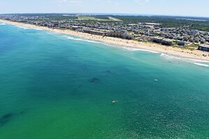
[[File:Triwrecks profile view.jpg|alt=High altitude profile view of the wrecks with town of Nag's Head and the Wright Memorial in the background|thumb|300x300px|High altitude profile view of the wrecks with town of Nag's Head and the Wright Memorial in the background]] | |||
There are two wrecks at this site, the [https://monitor.noaa.gov/shipwrecks/kyzikes.html Kyzikes] and the [https://monitor.noaa.gov/shipwrecks/carl_gerhard.html Carl Gerhard]. The ''Kyzikes'' ran aground first and the ''Carl Gerhard'' cut it in half two years later. The ''Carl Gerhard'' is the northernmost wreck. | |||
Guides can be booked via [https://roanokeislanddiveshop.com/ Roanoke Island Dive Shop]. They typically do not guide if the waves exceed ~2 ft. | |||
[https:// | |||
===Depth=== | ===Depth=== | ||
| Line 35: | Line 24: | ||
===Conditions=== | ===Conditions=== | ||
Conditions are highly variable | Conditions are highly variable. Expect currents and low visibility. | ||
===Facilities=== | ===Facilities=== | ||
| Line 44: | Line 30: | ||
==Access== | ==Access== | ||
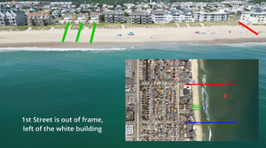
[[File:Triwrecks-overview.png|thumb|Annotated high aspect view of the site and the position of landmarks]] | |||
Via 2nd street public beach access, marked in red. There is limited street parking available, expect it to fill up quickly. If it's full there is also a beach access on 1st street but it's a longer walk to the entry area. | Via 2nd street public beach access, marked in red. There is limited street parking available, expect it to fill up quickly. If it's full there is also a beach access on 1st street but it's a longer walk to the entry area. | ||
Adjust where you get in so that prevailing currents will carry you to the wreck. | Adjust where you get in so that prevailing currents will carry you to the wreck. | ||
==Do== | ==Do== | ||
Find a suitable shore reference point. One of the buildings is a good choice. Swim out ~100m and use a snorkel from there to find the wreck. If the currents are up it may be easier to get in upstream, swim out and allow the current to carry you into the wreck. | Find a suitable shore reference point. One of the buildings is a good choice. Swim out ~100m and use a snorkel from there to find the wreck. If the currents are up it may be easier to get in upstream, swim out and allow the current to carry you into the wreck. | ||
==See== | ==See== | ||
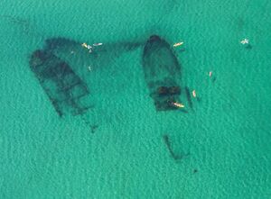
[[File:Triwreckplanview.jpg|thumb|Top down view of the two wrecks on a calm, high visibility day.]] | |||
===Life=== | |||
[[File:Triwreckplanview.jpg| | |||
=== | |||
There can be a lot of jellyfish on the surface, be wary of these when swimming out. | There can be a lot of jellyfish on the surface, be wary of these when swimming out. | ||
| Line 73: | Line 46: | ||
Angelfish may sometimes be found schooling near the wreck as well as miscellaneous small reef fish. | Angelfish may sometimes be found schooling near the wreck as well as miscellaneous small reef fish. | ||
==Safety== | ==Safety== | ||
===Hazards=== | ===Hazards=== | ||
| Line 88: | Line 55: | ||
* Silt clouds | * Silt clouds | ||
* Monofilament | * Monofilament | ||
Be especially wary when spearfishers and anglers are on the wreck, as they may mistake you for a fish. | |||
===Equipment=== | ===Equipment=== | ||
| Line 101: | Line 69: | ||
[https://qtube.qlyoung.net/w/uwynb9g1YuCT2XADzCumxr 2023 drone flyover] | [https://qtube.qlyoung.net/w/uwynb9g1YuCT2XADzCumxr 2023 drone flyover] | ||
[https://www.youtube.com/watch?v=f13ylcFaHJk 2019 | [https://www.youtube.com/watch?v=f13ylcFaHJk 2019 airplane flyover] | ||
==Nearby== | ==Nearby== | ||
==References== | |||
Latest revision as of 15:56, 4 January 2025
| Site Info | |
|---|---|
| Type | Wreck |
| Coordinates | 36.032611, -75.663972 |
| Region | Outer Banks |
| Access | Shore |
| Depth range | 5-20ft |
The Triangle Wrecks is a wreck dive near Nag's Head, NC in the Outer Banks. It is the site of two shipwrecks which form a rough triangle shape.
In a twist of fate, two vessels met their end in the identical spot, though two years separated their respective accidents. The Kyzikes, a tanker carrying crude oil en route to Spain, foundered in December 1927, due to a violent storm. The tempest led to water breaching the ship, consequently compromising its boiler tubes. Fast forward to 1929, the Carl Gerhard unfortunately met the same fate in that precise location, cutting through what remained of the Kyzikes. It was carrying a cargo of plasterboard.
Underwater, divers can spot debris, including a boiler, which collectively forms a triangular configuration, situated 15-20 feet deep. The dispersed remnants of these ill-fated ships stretch from 100 to 250 yards from the shoreline.[1][2]
Details[edit | edit source]

There are two wrecks at this site, the Kyzikes and the Carl Gerhard. The Kyzikes ran aground first and the Carl Gerhard cut it in half two years later. The Carl Gerhard is the northernmost wreck.
Guides can be booked via Roanoke Island Dive Shop. They typically do not guide if the waves exceed ~2 ft.
Depth[edit | edit source]
20ft to the sand.
Visibility[edit | edit source]
As low as 1ft, as high as 20ft. Increased currents typically correspond to lower visibility as they lift up silt from the bottom creating enormous silt clouds in the vicinity of the wreck.
Topography[edit | edit source]
Fine sandy bottom.
Conditions[edit | edit source]
Conditions are highly variable. Expect currents and low visibility.
Facilities[edit | edit source]
There are freshwater showers at the beach access which can be used to rinse self and gear. There are no changing rooms, public restrooms, or water fountains nearby. A lifeguard may be on duty.
Access[edit | edit source]

Via 2nd street public beach access, marked in red. There is limited street parking available, expect it to fill up quickly. If it's full there is also a beach access on 1st street but it's a longer walk to the entry area.
Adjust where you get in so that prevailing currents will carry you to the wreck.
Do[edit | edit source]
Find a suitable shore reference point. One of the buildings is a good choice. Swim out ~100m and use a snorkel from there to find the wreck. If the currents are up it may be easier to get in upstream, swim out and allow the current to carry you into the wreck.
See[edit | edit source]

Life[edit | edit source]
There can be a lot of jellyfish on the surface, be wary of these when swimming out.
Dolphins, skates and rays are not uncommon here.
Angelfish may sometimes be found schooling near the wreck as well as miscellaneous small reef fish.
Safety[edit | edit source]
Hazards[edit | edit source]
- Strong currents
- Stinging jellyfish
- Low visibility
- Silt clouds
- Monofilament
Be especially wary when spearfishers and anglers are on the wreck, as they may mistake you for a fish.
Equipment[edit | edit source]
- Full wetsuit recommended due to jellyfish
- Cutting device (or two); monofilament is on the wreck
- Flashlight recommended
- Snorkel - useful for spotting the wreck