Triangle Wrecks: Difference between revisions
| Line 22: | Line 22: | ||
==Details== | ==Details== | ||
===Position=== | ===Position ===<!--===Name=== | ||
<!--===Name=== | |||
[[Image:Image of whatever the site is named after.jpg|thumb|Caption]]--><!--nice if you can get it--> | [[Image:Image of whatever the site is named after.jpg|thumb|Caption]]--><!--nice if you can get it--> | ||
<!--The name "Site name" is derived from (derivation of site name)--> | <!--The name "Site name" is derived from (derivation of site name)--> | ||
===Depth=== | ===Depth=== | ||
20ft to the sand. | |||
===Visibility=== | ===Visibility=== | ||
As low as 1ft, as high as 20ft. Increased currents typically correspond to lower visibility as they lift up silt from the bottom creating enormous silt clouds in the vicinity of the wreck. | |||
===Topography=== | ===Topography=== | ||
Fine sandy bottom. | |||
===Conditions=== | ===Conditions=== | ||
Conditions are highly variable. Roanoke Island Dive Shop will not guide if the waves exceed 2 ft. | |||
<!--The site is (usually) at it's best in (season1) but there are also occasional opportunities in (season2) and (season3).--> | <!--The site is (usually) at it's best in (season1) but there are also occasional opportunities in (season2) and (season3).--> | ||
<!--This is an area which sometimes has (special circumstance), caused by (condition1), resulting in (condition2)--> | <!--This is an area which sometimes has (special circumstance), caused by (condition1), resulting in (condition2)--> | ||
<!--===Facilities===--> | <!--===Facilities===--> | ||
<!--Amenities AT the site, available for the convenience of the diver, such as off road parking, secure parking, ablution facilities, changing rooms, fresh water on tap, restaurant or fast food stall within immediate walking distance from the entry/parking area --> | <!--Amenities AT the site, available for the convenience of the diver, such as off road parking, secure parking, ablution facilities, changing rooms, fresh water on tap, restaurant or fast food stall within immediate walking distance from the entry/parking area --> | ||
==Access== | ==Access== | ||
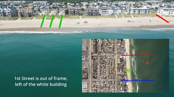
Via 2nd street public beach access, marked in red. There is limited street parking available, expect it to fill up quickly. If it's full there is also a beach access on 1st street but it's a longer walk to the entry area. | |||
Adjust where you get in so that prevailing currents will carry you to the wreck. | |||
[[File:Triwrecks-overview.png|600px]] | |||
==Do== | ==Do== | ||
<!--if there are two or more drop spots--> | <!--if there are two or more drop spots--> | ||
Revision as of 20:14, 17 August 2023
| Site Info | |
|---|---|
| Coordinates | {{{coords}}} |
| Region | {{{region}}} |
| Access via | {{{site_access_type}}} |
| Depth range | {{{depth_range}}} |
The Triangle Wrecks is a wreck dive near Nag's Head, NC in the United States.
Two ships had the misfortune of running ashore in the same location but two years apart. December of 1927 marked the sinking of the first ship, The Kyzickes. The Kyzickes was a tanker bound for Spain with a cargo full of crude oil when it was caught in a storm. The strong winds caused the ship to take on water, ultimately destroying the boiler tubes. In 1929, the vessel Carl Gerhard also managed to run aground at the exact same location, slicing through the remains of The Kyzickes. Below the water line, you can see wreckage including a boiler. The wreckage takes the shape of a “triangle” and lies in about 15-20 feet of water. The scattered chunks of both wrecks can be found starting at 100 yards and ranging to 250 yards offshore.
Details
Position
Depth
20ft to the sand.
Visibility
As low as 1ft, as high as 20ft. Increased currents typically correspond to lower visibility as they lift up silt from the bottom creating enormous silt clouds in the vicinity of the wreck.
Topography
Fine sandy bottom.
Conditions
Conditions are highly variable. Roanoke Island Dive Shop will not guide if the waves exceed 2 ft.
Access
Via 2nd street public beach access, marked in red. There is limited street parking available, expect it to fill up quickly. If it's full there is also a beach access on 1st street but it's a longer walk to the entry area.
Adjust where you get in so that prevailing currents will carry you to the wreck.
Do
Routes
See
Features
Marine life
Photography
Safety
Hazards
Equipment
Media
Nearby
Lua error in package.lua at line 80: module 'Module:Arguments' not found.
