Mystery Lake: Difference between revisions
Change coordinates to decimal |
No edit summary Tags: Mobile edit Mobile web edit |
||
| Line 9: | Line 9: | ||
It is sometimes used for diver training. DAN, which maintains its global headquarters in Durham about 45 minutes away, conducts research here as well. | It is sometimes used for diver training. DAN, which maintains its global headquarters in Durham about 45 minutes away, conducts research here as well. | ||
This site is much less frequently visited than nearby [[Fantasy Lake]], primarily due to its poor visibility, | This site is much less frequently visited than nearby [[Fantasy Lake]], primarily due to its poor visibility, challenging training conditions, colder temperatures and increased depths. | ||
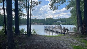
[[File:Mystery Lake.jpg|alt=View of Mystery Lake from the southeast beach access|thumb|View of Mystery Lake from the southeast beach access]] | [[File:Mystery Lake.jpg|alt=View of Mystery Lake from the southeast beach access|thumb|View of Mystery Lake from the southeast beach access]] | ||
Revision as of 13:56, 19 June 2024
| Site Info | |
|---|---|
| Type | Lake |
| Coordinates | 35.787056, -78.343667 |
| Region | Eastern US |
| Access | Shore |
| Depth range | 10-100ft |
Mystery Lake[1] is a privately owned freshwater lake formed from a flooded quarry. It is located in the town of Wendell, NC in the United States.
It is sometimes used for diver training. DAN, which maintains its global headquarters in Durham about 45 minutes away, conducts research here as well.
This site is much less frequently visited than nearby Fantasy Lake, primarily due to its poor visibility, challenging training conditions, colder temperatures and increased depths.

Details
History
Mystery Lake was once a rock quarry.
Location
536 Old Quarry Rd
Wendell, NC 27591
Depth
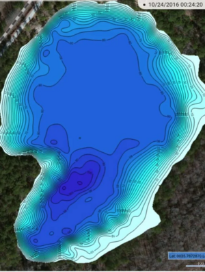
Mystery Lake is a deep quarry. There is a shallow bank around the eastern half of the lake with depths between 15-20 ft. Elsewhere depths are typically in the 70-80ft range. The deepest point in the quarry is 100ft; there is a training platform at this location.
Topography

The bottom is silty. There are a variety of submerged features with lines running between most of them.
Aerators have been installed in an attempt to improve visibility and to eliminate the thermocline.
Conditions
Visibility varies with depth but is typically in the 5-10ft range. Occasionally it may extend up to 30ft but this is rare. Visibility tends to be best in the 40-60ft range.
Conditions are sporadically reported on the site's Facebook page.
Facilities
- One changing room at the southeastern beach entry
- Two portable restrooms
- Two covered awnings with picnic tables and gear benches, one at each access
Access
The property is gated and access is restricted to holders of annual passes, which can be purchased from the owners. Passholders receive a gate code that may be used to access the site at any time. The owners reside on the property.
For information on how to get a pass refer to the website.
There is ample parking at both entry sites.
Do
See
There are many submerged features in the quarry ranging from abandoned quarrying equipment to intentionally sunken vehicles. There are also two training platforms.
Life
A small population of freshwater paddlefish reside in the quarry. It is very rare to see them.
Safety
Hazards
Equipment
Nearby
Fantasy Lake is located 13 miles away.
References