(Created page with "{{Divesite_infobox |coordinates= |region=US Atlantic coast |site_access_type=Shore |depth_range=10ft |Type=Wreck}} <!-- General description of the site! --> The tugboat ''Explorer'' is a shoreline wreck near the city of Nag's Head in the Outer Banks of North Carolina. ==Details== ===Location=== The tugboat ''Explorer'' lies roughly halfway between the Huron and Nag's Head Fishing Pier to the south. It is in about 10 ft of water. Online reports suggest it can be dived on...") |
(Remove topography heading, right align static map) |
||
| (9 intermediate revisions by 2 users not shown) | |||
| Line 1: | Line 1: | ||
{{Divesite_infobox | {{Divesite_infobox | ||
|coordinates= | |coordinates=35.974556, -75.630167 | ||
|region=US Atlantic coast | |region=US Atlantic coast | ||
|site_access_type=Shore | |site_access_type=Shore | ||
|depth_range=10ft | |depth_range=10ft | ||
| | |type=Ocean}} | ||
<!-- General description of the site! --> | <!-- General description of the site! --> | ||
The tugboat ''Explorer'' is a shoreline wreck near the city of Nag's Head in the Outer Banks of North Carolina. | The tugboat ''Explorer'' is a shoreline wreck near the city of Nag's Head in the Outer Banks of North Carolina. | ||
==Details== | ==Details== | ||
===Location=== | ===Location=== | ||
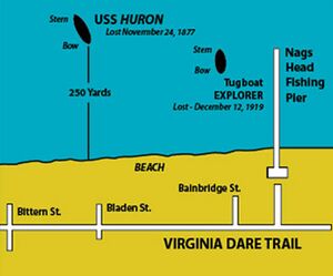
The tugboat ''Explorer'' lies roughly halfway between the Huron and Nag's Head Fishing Pier to the south | The tugboat ''Explorer'' lies roughly halfway between the [[USS Huron]] and Nag's Head Fishing Pier to the south. Online reports suggest it can be dived on the return swim from the Huron.<ref name="shorediving">https://web.archive.org/web/20161225090020/http://www.shorediving.com/Earth/USA_East/North_Carolina/USS_Huron/index.htm</ref> | ||
===Depth=== | ===Depth=== | ||
Reported to be 10ft<ref name="shorediving" /> | Reported to be 10ft.<ref name="shorediving" /> | ||
[[File:Outer banks huron map.jpg|align=right|alt=Sketch map showing location of the tugboat Explorer relative to the USS Huron and Nag's Head Fishing Pier|thumb|Sketch map showing location of the tugboat Explorer relative to the USS Huron and Nag's Head Fishing Pier]] | |||
===Conditions=== | ===Conditions=== | ||
Presumably similar to those of the Huron. | |||
==Access== | ==Access== | ||
| Line 65: | Line 54: | ||
==Nearby== | ==Nearby== | ||
[[USS Huron]] | |||
==References== | ==References== | ||
| Line 74: | Line 62: | ||
[[Category:Dive sites]] | [[Category:Dive sites]] | ||
{{IsPartOf|Outer Banks}} | |||
{{DISPLAYTITLE:Tugboat ''Explorer''}} | |||
Latest revision as of 05:32, 22 May 2024
| Site Info | |
|---|---|
| Type | Ocean |
| Coordinates | 35.974556, -75.630167 |
| Region | US Atlantic coast |
| Access via | Shore |
| Depth range | 10ft |
The tugboat Explorer is a shoreline wreck near the city of Nag's Head in the Outer Banks of North Carolina.
Details[edit | edit source]
Location[edit | edit source]
The tugboat Explorer lies roughly halfway between the USS Huron and Nag's Head Fishing Pier to the south. Online reports suggest it can be dived on the return swim from the Huron.[1]
Depth[edit | edit source]
Reported to be 10ft.[1]

Conditions[edit | edit source]
Presumably similar to those of the Huron.
Access[edit | edit source]
Do[edit | edit source]
See[edit | edit source]
Life[edit | edit source]
Safety[edit | edit source]
Hazards[edit | edit source]
Equipment[edit | edit source]
Nearby[edit | edit source]
References[edit | edit source]