USS Huron
| Site Info | |
|---|---|
| Type | Wreck |
| Coordinates | 35.977500, -75.630917 |
| Region | Outer Banks |
| Access | Shore |
| Depth range | 5-30ft |

The USS Huron is a shoreline historical wreck near Nag's Head in the Outer Banks of NC.
Divers and snorkelers who visit the site can see a wide variety of sea life as they swim over the remains of the historic warship. Many portions of the wreck hold points of interest such as boilers, cannonball storage racks, and the huge propeller and rudder.
During the 1870s, the ship's cannons and much of its machinery were salvaged. Over the years, time and the elements have eroded parts of the ship. The lower hull is well preserved, however, and portions of the bow remain intact up to the main deck level. A thick layer of concretion and marine growth now covers the site, hiding many structural features. Because the Huron site is close to shore, shifting sands are constantly covering and uncovering various portions of the wreck.[1]
Details[edit | edit source]
History[edit | edit source]

Built a decade after the Civil War, USS Huron was constructed during a period of transition between the old and new navy. Huron and its two sister ships were the last American naval vessels to be built of iron rather than steel and to be equipped with sails to supplement their steam engines.
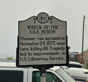
The Huron departed Hampton Roads on 23 November 1877 for a scientific cruise on the coast of Cuba. Soon after her departure, Huron ran aground off Nags Head, North Carolina in heavy weather, and was wrecked shortly after 1 a.m. next morning. For a time, her crew worked in relatively little danger, attempting to free their ship, but she soon heeled over, carrying 98 officers and men to their deaths. Of the fatalities 83 remains were recovered and buried; of which the remains of 8 officers and 61 men were identified while 14 others could not be identified.[2][3]
Location[edit | edit source]

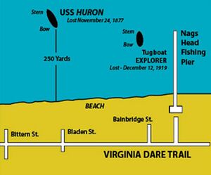
The Huron is approximately 250 yards off Bladen Street beach in Nag's Head, between mileposts 11 and 12.[4] During the summer months, buoys mark the bow and stern of the wreck.[1]
An informational exhibit is located in the gazebo at the Bladen Street beach access.[1]
Depth[edit | edit source]
5-30ft.
Topography[edit | edit source]
Profile and plan view sketches of the wreck site can be found on the Underwater Archaeology Bureau of NC website.[1]
Conditions[edit | edit source]
Visibility is reported to be typically between 5-10 ft.[4]
Facilities[edit | edit source]
There are freshwater showers at the beach access that can be used for rinsing.
Rules[edit | edit source]
Collecting artifacts from the wreck is prohibited. USS Huron and other shipwreck sites in North Carolina waters are protected by state and federal law. It is illegal to remove artifacts or disturb a shipwreck site without a valid permit. If you observe an unusual or important artifact, please do not disturb it. Note the artifact's location and report it to the Underwater Archaeology Branch or local authorities.
Access[edit | edit source]
Do[edit | edit source]
See[edit | edit source]
Life[edit | edit source]
You may encounter sea turtles, porpoises, starfish, lobster, rays and skates, sharks, angelfish and grouper.
Bull and hammerhead sharks have been reported around the wreck.
Safety[edit | edit source]
Full body covering (wetsuit, skinsuit etc) recommended as the waters can contain jellyfish. Be wary of poor visibility and shifting currents.
Hazards[edit | edit source]
Popular site for spearfishers and anglers.
Equipment[edit | edit source]
Nearby[edit | edit source]
Media[edit | edit source]
References[edit | edit source]
- ↑ Jump up to: 1.0 1.1 1.2 1.3 https://archaeology.ncdcr.gov/uab/heritage-dive-sites/huron
- ↑ https://en.wikipedia.org/wiki/USS_Huron_(1875)
- ↑ https://outerbankscoastallife.com/uss-huron/
- ↑ Jump up to: 4.0 4.1 https://web.archive.org/web/20161225090020/http://www.shorediving.com/Earth/USA_East/North_Carolina/USS_Huron/index.htm